São Joaquim night lights from space
Night Light of São Joaquim (Santa Catarina) from space (Brazil) Src. Average luminocity for 10x10km area is 10.9385% and for 50x50km: 0.4393%.
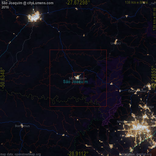
Analysis of São Joaquim night lights 2016
Square area 10x10 km:
 0.79%
0.79%90-99
1.59%80-89
0.6%70-79
1.59%60-69
2.98%50-59
4.37%40-49
0%30-39
0.79%20-29
0.79%10-19
0%0-9
86.51%Square area 50x50 km:
0.03%90-99
0.06%80-89
0.02%70-79
0.06%60-69
0.11%50-59
0.17%40-49
0%30-39
0.03%20-29
0.03%10-19
0%0-9
99.48%Clear (daylight) street map image can be seen on geolist.org.
Map coordinates:
27° 40' 22.7" South, 50° 38' 5.3" West
28° 17' 38" South, 49° 55' 54" West
28° 54' 40.3" South, 49° 13' 42.8" West
Some cities around São Joaquim sort by population:
• Lages
65.7 km =40.8 mi,  323°
323°
• Criciúma
69.5 km =43.2 mi,  127°
127°
• Forquilhinha
67.5 km =41.9 mi,  138°
138°
• Orleans
63.1 km =39.2 mi,  96°
96°
• Cocal
68.3 km =42.4 mi,  120°
120°
• Urussanga
64.7 km =40.2 mi,  112°
112°
• Lauro Muller
53.5 km =33.2 mi, 101°
• Siderópolis
60 km =37.3 mi, 124°
3448828 (p: 16,250)
Sources (retrieved 2019-11-25):
» Earth at Night: Flat Maps 2012, 2016