Aquidabã night lights from space
Night Light of Aquidabã (Sergipe) from space (Brazil) Src. Average luminocity for 10x10km area is 26.5248% and for 50x50km: 11.5989%.
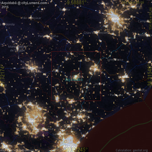
Analysis of Aquidabã night lights 2016
Square area 10x10 km:
 1.45%
1.45%90-99
3.1%80-89
2.07%70-79
4.55%60-69
5.37%50-59
4.75%40-49
6.2%30-39
3.31%20-29
4.96%10-19
30.17%0-9
34.09%Square area 50x50 km:
0.4%90-99
1.65%80-89
0.66%70-79
1.39%60-69
1.48%50-59
2.84%40-49
2.22%30-39
1.87%20-29
2.54%10-19
8.22%0-9
76.73%Clear (daylight) street map image can be seen on geolist.org.
Map coordinates:
9° 35' 19.7" South, 37° 43' 18.3" West
10° 16' 53" South, 37° 1' 7" West
10° 58' 20.8" South, 36° 18' 55.8" West
Some cities around Aquidabã sort by population:
• Penedo
47.3 km =29.4 mi,  91°
91°
• Propriá
21 km =13 mi,  68°
68°
• Nossa Senhora da Glória
44.5 km =27.7 mi,  279°
279°
• Capela
25 km =15.5 mi,  188°
188°
• Nossa Senhora das Dores
30.2 km =18.8 mi,  219°
219°
• Traipu
34.6 km =21.5 mi,  2°
2°
• Japaratuba
35.7 km =22.2 mi,  166°
166°
• Porto Real do Colégio
22.2 km =13.8 mi,  61°
61°
3471902 (p: 10,596)
Sources (retrieved 2019-11-25):
» Earth at Night: Flat Maps 2012, 2016