Mutum night lights from space
Night Light of Mutum (Minas Gerais) from space (Brazil) Src. Average luminocity for 10x10km area is 5.8388% and for 50x50km: 0.6502%.
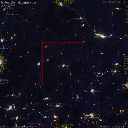
Analysis of Mutum night lights 2016
Square area 10x10 km:
 0.62%
0.62%90-99
0.21%80-89
2.48%70-79
1.65%60-69
0%50-59
0%40-49
0.83%30-39
0.83%20-29
1.45%10-19
0.21%0-9
91.74%Square area 50x50 km:
0.02%90-99
0.01%80-89
0.13%70-79
0.13%60-69
0.06%50-59
0.2%40-49
0.19%30-39
0.11%20-29
0.22%10-19
0.04%0-9
98.88%Clear (daylight) street map image can be seen on geolist.org.
Map coordinates:
19° 8' 13.5" South, 42° 8' 29.3" West
19° 48' 0" South, 41° 26' 18" West
20° 27' 36.6" South, 40° 44' 6.8" West
Some cities around Mutum sort by population:
• Baixo Guandu
54.2 km =33.7 mi,  54°
54°
• Aimorés
51.8 km =32.2 mi, 49°
• Lajinha
43.6 km =27.1 mi,  206°
206°
• Resplendor
56.1 km =34.9 mi,  19°
19°
• Iúna
61.5 km =38.2 mi,  189°
189°
• Afonso Cláudio
44.8 km =27.8 mi,  132°
132°
• Ibatiba
48.8 km =30.3 mi, 188°
• Itaguaçu
61 km =37.9 mi,  90°
90°
3456445 (p: 12,582)
Sources (retrieved 2019-11-25):
» Earth at Night: Flat Maps 2012, 2016