Iúna night lights from space
Night Light of Iúna (Espírito Santo) from space (Brazil) Src. Average luminocity for 10x10km area is 10.3049% and for 50x50km: 2.4181%.
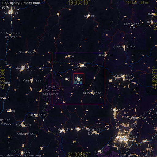
Analysis of Iúna night lights 2016
Square area 10x10 km:
 1.52%
1.52%90-99
1.52%80-89
0.95%70-79
3.6%60-69
0%50-59
0.76%40-49
0%30-39
1.52%20-29
2.84%10-19
0.19%0-9
87.12%Square area 50x50 km:
0.15%90-99
0.18%80-89
0.42%70-79
0.61%60-69
0.22%50-59
0.26%40-49
0.49%30-39
0.45%20-29
0.43%10-19
0.26%0-9
96.54%Clear (daylight) street map image can be seen on geolist.org.
Map coordinates:
19° 41' 6.6" South, 42° 14' 20.3" West
20° 20' 45" South, 41° 32' 9" West
21° 0' 13.2" South, 40° 49' 57.8" West
Some cities around Iúna sort by population:
• Castelo
46.5 km =28.9 mi,  128°
128°
• Guaçuí
50.1 km =31.1 mi,  197°
197°
• Alegre
46.5 km =28.9 mi,  179°
179°
• Lajinha
23.4 km =14.5 mi,  337°
337°
• Manhumirim
44 km =27.3 mi,  268°
268°
• Espera Feliz
51.4 km =31.9 mi,  228°
228°
• Ibatiba
12.7 km =7.9 mi,  11°
11°
• Muniz Freire
18.4 km =11.4 mi,  135°
135°
3460505 (p: 14,290)
Sources (retrieved 2019-11-25):
» Earth at Night: Flat Maps 2012, 2016