Ibatiba night lights from space
Night Light of Ibatiba (Espírito Santo) from space (Brazil) Src. Average luminocity for 10x10km area is 11.7698% and for 50x50km: 2.2256%.
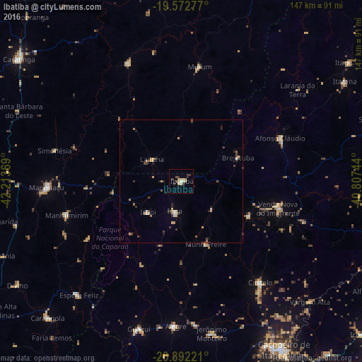
Analysis of Ibatiba night lights 2016
Square area 10x10 km:
 1.19%
1.19%90-99
0.99%80-89
2.38%70-79
2.38%60-69
0.99%50-59
0.79%40-49
0.99%30-39
4.37%20-29
0.99%10-19
0.4%0-9
84.52%Square area 50x50 km:
0.15%90-99
0.16%80-89
0.39%70-79
0.51%60-69
0.15%50-59
0.28%40-49
0.47%30-39
0.48%20-29
0.4%10-19
0.28%0-9
96.73%Clear (daylight) street map image can be seen on geolist.org.
Map coordinates:
19° 34' 22" South, 42° 12' 49.3" West
20° 14' 2" South, 41° 30' 38" West
20° 53' 32" South, 40° 48' 26.8" West
Some cities around Ibatiba sort by population:
• Manhuaçu
54.6 km =33.9 mi,  267°
267°
• Castelo
53.3 km =33.1 mi,  140°
140°
• Lajinha
14.9 km =9.3 mi,  308°
308°
• Manhumirim
48.7 km =30.3 mi,  253°
253°
• Iúna
12.7 km =7.9 mi,  191°
191°
• Afonso Cláudio
44.1 km =27.4 mi,  66°
66°
• Mutum
48.8 km =30.3 mi,  8°
8°
• Muniz Freire
27.5 km =17.1 mi,  158°
158°
3461624 (p: 12,265)
Sources (retrieved 2019-11-25):
» Earth at Night: Flat Maps 2012, 2016