Miranda night lights from space
Night Light of Miranda (Mato Grosso do Sul) from space (Brazil) Src. Average luminocity for 10x10km area is 14.123% and for 50x50km: 0.7456%.
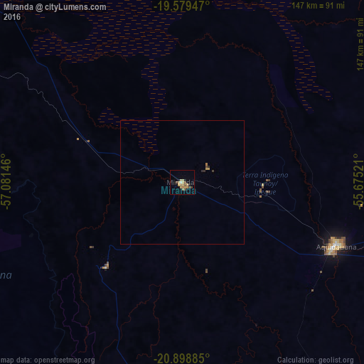
Analysis of Miranda night lights 2016
Square area 10x10 km:
 0.4%
0.4%90-99
0.4%80-89
4.37%70-79
4.17%60-69
1.79%50-59
1.39%40-49
2.58%30-39
0.79%20-29
1.98%10-19
0.6%0-9
81.55%Square area 50x50 km:
0.02%90-99
0.02%80-89
0.19%70-79
0.21%60-69
0.1%50-59
0.06%40-49
0.15%30-39
0.08%20-29
0.14%10-19
0.02%0-9
99.01%Clear (daylight) street map image can be seen on geolist.org.
Map coordinates:
19° 34' 46.1" South, 57° 4' 53.3" West
20° 14' 26" South, 56° 22' 42" West
20° 53' 55.9" South, 55° 40' 30.8" West
Some cities around Miranda sort by population:
• Aquidauana
66.7 km =41.4 mi,  112°
112°
• Jardim
140.1 km =87.1 mi,  169°
169°
• Anastácio
65.4 km =40.6 mi, 114°
• Sidrolândia
166.3 km =103.3 mi,  117°
117°
• Bonito
98.5 km =61.2 mi,  186°
186°
• Guia Lopes da Laguna
138.1 km =85.8 mi, 168°
• Terenos
159.8 km =99.3 mi,  98°
98°
• Fuerte Olimpo, PY
179.3 km =111.4 mi,  240°
240°
3457113 (p: 13,189)
Sources (retrieved 2019-11-25):
» Earth at Night: Flat Maps 2012, 2016