Maribondo night lights from space
Night Light of Maribondo (Alagoas) from space (Brazil) Src. Average luminocity for 10x10km area is 5.8009% and for 50x50km: 7.3939%.
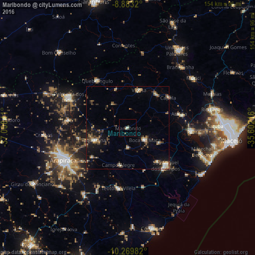
Analysis of Maribondo night lights 2016
Square area 10x10 km:
 0%
0%90-99
2.6%80-89
0%70-79
0%60-69
1.73%50-59
0%40-49
1.52%30-39
1.08%20-29
0.43%10-19
0.43%0-9
92.21%Square area 50x50 km:
0.2%90-99
1.35%80-89
0.61%70-79
0.66%60-69
0.97%50-59
1.44%40-49
1.72%30-39
1.49%20-29
1.55%10-19
4.43%0-9
85.58%Clear (daylight) street map image can be seen on geolist.org.
Map coordinates:
8° 52' 59.5" South, 37° 0' 30.3" West
9° 34' 38" South, 36° 18' 19" West
10° 16' 11.4" South, 35° 36' 7.8" West
Some cities around Maribondo sort by population:
• São Miguel dos Campos
32.4 km =20.1 mi,  134°
134°
• Viçosa
24 km =14.9 mi,  17°
17°
• Atalaia
32.1 km =19.9 mi,  74°
74°
• Campo Alegre
23.3 km =14.5 mi,  192°
192°
• Cajueiro
22.2 km =13.8 mi,  225°
225°
• Capela
31.6 km =19.6 mi,  53°
53°
• Anadia
11.9 km =7.4 mi,  179°
179°
• Taquarana
22.4 km =13.9 mi,  250°
250°
3395336 (p: 10,475)
Sources (retrieved 2019-11-25):
» Earth at Night: Flat Maps 2012, 2016