Campo Alegre night lights from space
Night Light of Campo Alegre (Alagoas) from space (Brazil) Src. Average luminocity for 10x10km area is 5.7771% and for 50x50km: 9.3648%.
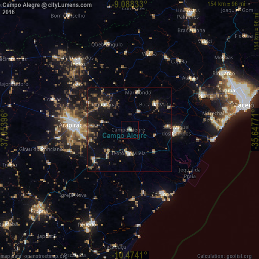
Analysis of Campo Alegre night lights 2016
Square area 10x10 km:
 0%
0%90-99
1.95%80-89
0.65%70-79
0%60-69
0%50-59
0.87%40-49
0.87%30-39
3.9%20-29
1.3%10-19
0%0-9
90.48%Square area 50x50 km:
0.27%90-99
1.17%80-89
0.59%70-79
0.8%60-69
1.34%50-59
2.17%40-49
2.14%30-39
1.82%20-29
2.67%10-19
7.53%0-9
79.51%Clear (daylight) street map image can be seen on geolist.org.
Map coordinates:
9° 5' 18" South, 37° 3' 14.3" West
9° 46' 55" South, 36° 21' 3" West
10° 28' 26.8" South, 35° 38' 51.8" West
Some cities around Campo Alegre sort by population:
• Arapiraca
34.2 km =21.3 mi,  275°
275°
• São Miguel dos Campos
28.2 km =17.5 mi,  89°
89°
• Cajueiro
13.1 km =8.1 mi,  303°
303°
• Maribondo
23.3 km =14.5 mi,  12°
12°
• Anadia
12 km =7.5 mi,  25°
25°
• São Sebastião
27.9 km =17.3 mi,  232°
232°
• Junqueiro
21 km =13 mi,  220°
220°
• Taquarana
22.1 km =13.7 mi,  313°
313°
3403611 (p: 16,785)
Sources (retrieved 2019-11-25):
» Earth at Night: Flat Maps 2012, 2016