Capela night lights from space
Night Light of Capela (Alagoas) from space (Brazil) Src. Average luminocity for 10x10km area is 6.7338% and for 50x50km: 6.948%.
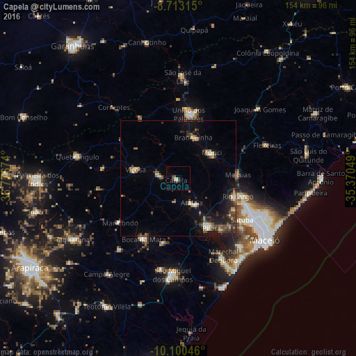
Analysis of Capela night lights 2016
Square area 10x10 km:
 0%
0%90-99
2.6%80-89
0%70-79
0%60-69
0.87%50-59
1.73%40-49
0.87%30-39
0.87%20-29
1.73%10-19
0.87%0-9
90.48%Square area 50x50 km:
0.18%90-99
1.28%80-89
0.54%70-79
0.6%60-69
0.87%50-59
1.18%40-49
1.36%30-39
1.64%20-29
1.9%10-19
4.92%0-9
85.52%Clear (daylight) street map image can be seen on geolist.org.
Map coordinates:
8° 42' 47.3" South, 36° 46' 36.3" West
9° 24' 27" South, 36° 4' 25" West
10° 6' 1.7" South, 35° 22' 13.8" West
Some cities around Capela sort by population:
• Rio Largo
25.4 km =15.8 mi,  108°
108°
• União dos Palmares
27.6 km =17.1 mi,  9°
9°
• Pilar
24.7 km =15.3 mi,  148°
148°
• Murici
18.2 km =11.3 mi,  51°
51°
• Viçosa
18.8 km =11.7 mi,  282°
282°
• Atalaia
11.9 km =7.4 mi, 152°
• Messias
25.6 km =15.9 mi,  83°
83°
• Santana do Mundaú
31.2 km =19.4 mi,  328°
328°
3403200 (p: 12,520)
Sources (retrieved 2019-11-25):
» Earth at Night: Flat Maps 2012, 2016