Taquarana night lights from space
Night Light of Taquarana (Alagoas) from space (Brazil) Src. Average luminocity for 10x10km area is 35.9913% and for 50x50km: 19.5402%.
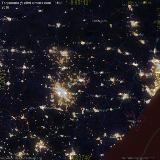
Analysis of Taquarana night lights 2016
Square area 10x10 km:
 1.08%
1.08%90-99
5.19%80-89
1.52%70-79
5.19%60-69
8.01%50-59
7.36%40-49
7.58%30-39
9.52%20-29
11.26%10-19
41.13%0-9
2.16%Square area 50x50 km:
1.28%90-99
3.07%80-89
1.51%70-79
1.96%60-69
3.3%50-59
4.53%40-49
4.66%30-39
4.3%20-29
6.43%10-19
13.33%0-9
55.63%Clear (daylight) street map image can be seen on geolist.org.
Map coordinates:
8° 57' 4" South, 37° 12' 1.3" West
9° 38' 42" South, 36° 29' 50" West
10° 20' 14.9" South, 35° 47' 38.8" West
Some cities around Taquarana sort by population:
• Arapiraca
21.6 km =13.4 mi,  236°
236°
• Campo Alegre
22.1 km =13.7 mi,  133°
133°
• Cajueiro
9.5 km =5.9 mi,  146°
146°
• Maribondo
22.4 km =13.9 mi,  70°
70°
• Anadia
21.6 km =13.4 mi,  101°
101°
• São Sebastião
32.7 km =20.3 mi,  191°
191°
• Junqueiro
31.3 km =19.4 mi,  175°
175°
• Igaci
19.2 km =11.9 mi,  308°
308°
3386628 (p: 5,288)
Sources (retrieved 2019-11-25):
» Earth at Night: Flat Maps 2012, 2016