Cajueiro night lights from space
Night Light of Cajueiro (Alagoas) from space (Brazil) Src. Average luminocity for 10x10km area is 7.3117% and for 50x50km: 16.6437%.
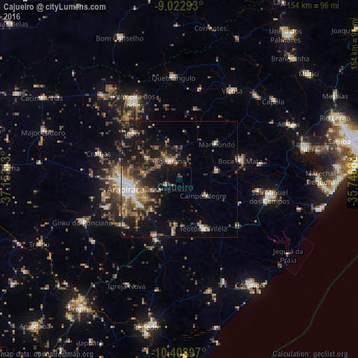
Analysis of Cajueiro night lights 2016
Square area 10x10 km:
 0%
0%90-99
0%80-89
0.65%70-79
0.22%60-69
0%50-59
1.73%40-49
3.25%30-39
1.95%20-29
1.73%10-19
6.49%0-9
83.98%Square area 50x50 km:
1.26%90-99
2.56%80-89
1.28%70-79
1.53%60-69
2.79%50-59
3.79%40-49
3.69%30-39
3.05%20-29
4.57%10-19
12.01%0-9
63.46%Clear (daylight) street map image can be seen on geolist.org.
Map coordinates:
9° 1' 22.5" South, 37° 9' 11.3" West
9° 43' 0" South, 36° 27' 0" West
10° 24' 32.3" South, 35° 44' 48.8" West
Some cities around Cajueiro sort by population:
• Arapiraca
23.5 km =14.6 mi,  260°
260°
• Campo Alegre
13.1 km =8.1 mi,  123°
123°
• Maribondo
22.2 km =13.8 mi,  45°
45°
• Anadia
16.4 km =10.2 mi,  77°
77°
• São Sebastião
26.7 km =16.6 mi,  205°
205°
• Junqueiro
23.4 km =14.5 mi,  186°
186°
• Igaci
28.4 km =17.6 mi,  314°
314°
• Taquarana
9.5 km =5.9 mi,  326°
326°
3403941 (p: 15,062)
Sources (retrieved 2019-11-25):
» Earth at Night: Flat Maps 2012, 2016