Atalaia night lights from space
Night Light of Atalaia (Alagoas) from space (Brazil) Src. Average luminocity for 10x10km area is 14.342% and for 50x50km: 12.7833%.
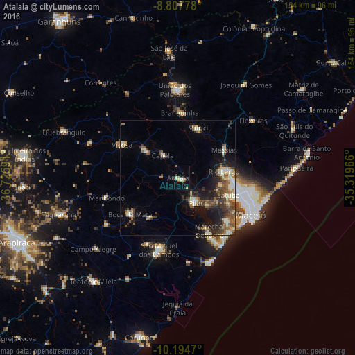
Analysis of Atalaia night lights 2016
Square area 10x10 km:
 0%
0%90-99
4.11%80-89
2.16%70-79
1.95%60-69
0.87%50-59
1.08%40-49
2.38%30-39
2.6%20-29
1.73%10-19
3.46%0-9
79.65%Square area 50x50 km:
0.58%90-99
3.08%80-89
1.12%70-79
1.28%60-69
1.64%50-59
2.47%40-49
2.68%30-39
2.48%20-29
3.23%10-19
6.67%0-9
74.76%Clear (daylight) street map image can be seen on geolist.org.
Map coordinates:
8° 48' 28" South, 36° 43' 33.3" West
9° 30' 7" South, 36° 1' 22" West
10° 11' 40.9" South, 35° 19' 10.8" West
Some cities around Atalaia sort by population:
• Rio Largo
18.8 km =11.7 mi,  81°
81°
• Marechal Deodoro
27.1 km =16.8 mi,  148°
148°
• Pilar
12.8 km =8 mi, 145°
• Murici
23.4 km =14.5 mi,  21°
21°
• Viçosa
28 km =17.4 mi,  301°
301°
• Satuba
22.8 km =14.2 mi,  107°
107°
• Capela
11.9 km =7.4 mi,  332°
332°
• Messias
23.8 km =14.8 mi,  56°
56°
3406996 (p: 18,908)
Sources (retrieved 2019-11-25):
» Earth at Night: Flat Maps 2012, 2016