Sertanópolis night lights from space
Night Light of Sertanópolis (Paraná) from space (Brazil) Src. Average luminocity for 10x10km area is 13.7222% and for 50x50km: 6.4293%.
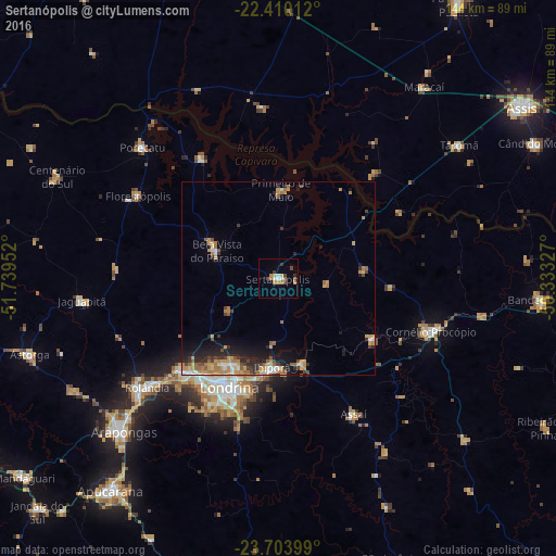
Analysis of Sertanópolis night lights 2016
Square area 10x10 km:
 1.39%
1.39%90-99
1.79%80-89
0.79%70-79
3.37%60-69
2.98%50-59
0.79%40-49
2.98%30-39
1.79%20-29
0.79%10-19
0.6%0-9
82.74%Square area 50x50 km:
0.57%90-99
0.66%80-89
0.63%70-79
1.64%60-69
1.38%50-59
0.8%40-49
0.75%30-39
0.93%20-29
1.62%10-19
3.13%0-9
87.89%Clear (daylight) street map image can be seen on geolist.org.
Map coordinates:
22° 24' 36.4" South, 51° 44' 22.3" West
23° 3' 31" South, 51° 2' 11" West
23° 42' 14.4" South, 50° 19' 59.8" West
Some cities around Sertanópolis sort by population:
• Londrina
30.8 km =19.1 mi,  204°
204°
• Cambé
34.6 km =21.5 mi,  225°
225°
• Cornélio Procópio
42.1 km =26.2 mi,  108°
108°
• Ibiporã
23.4 km =14.5 mi,  182°
182°
• Bela Vista do Paraíso
17.2 km =10.7 mi,  293°
293°
• Florestópolis
42 km =26.1 mi,  301°
301°
• Assaí
40.3 km =25 mi,  150°
150°
• Jataizinho
22.5 km =14 mi,  165°
165°
3447658 (p: 13,903)
Sources (retrieved 2019-11-25):
» Earth at Night: Flat Maps 2012, 2016