Lapão night lights from space
Night Light of Lapão (Bahia) from space (Brazil) Src. Average luminocity for 10x10km area is 13.3009% and for 50x50km: 4.5815%.
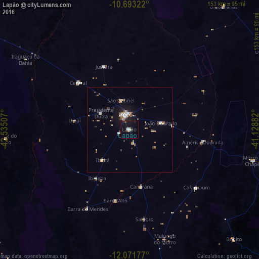
Analysis of Lapão night lights 2016
Square area 10x10 km:
 2.81%
2.81%90-99
1.52%80-89
0%70-79
0%60-69
1.73%50-59
1.08%40-49
1.3%30-39
1.95%20-29
0.87%10-19
20.78%0-9
67.97%Square area 50x50 km:
0.7%90-99
0.71%80-89
0.38%70-79
0.22%60-69
0.54%50-59
0.9%40-49
0.65%30-39
0.38%20-29
0.73%10-19
3.25%0-9
91.55%Clear (daylight) street map image can be seen on geolist.org.
Map coordinates:
10° 41' 35.6" South, 42° 32' 6.3" West
11° 22' 60" South, 41° 49' 55" West
12° 4' 18.4" South, 41° 7' 43.8" West
Some cities around Lapão sort by population:
• Irecê
9.2 km =5.7 mi,  343°
343°
• Morro do Chapéu
75.7 km =47 mi,  104°
104°
• Ibipeba
34.7 km =21.6 mi,  214°
214°
• Barro Alto
42.9 km =26.7 mi,  191°
191°
• América Dourada
43.9 km =27.3 mi, 100°
• Cafarnaum
52.5 km =32.6 mi,  131°
131°
• Canarana
34.2 km =21.3 mi,  168°
168°
• Iraquara
99 km =61.5 mi, 166°
3458817 (p: 11,252)
Sources (retrieved 2019-11-25):
» Earth at Night: Flat Maps 2012, 2016