Ribeirão Bonito night lights from space
Night Light of Ribeirão Bonito (São Paulo) from space (Brazil) Src. Average luminocity for 10x10km area is 5.9365% and for 50x50km: 3.5364%.
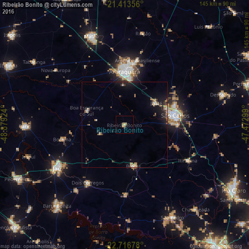
Analysis of Ribeirão Bonito night lights 2016
Square area 10x10 km:
 0%
0%90-99
0.6%80-89
0.99%70-79
1.98%60-69
2.18%50-59
0.6%40-49
0%30-39
0%20-29
0.79%10-19
1.59%0-9
91.27%Square area 50x50 km:
0.17%90-99
0.33%80-89
0.32%70-79
0.67%60-69
0.6%50-59
0.28%40-49
0.48%30-39
0.6%20-29
1.12%10-19
3.28%0-9
92.14%Clear (daylight) street map image can be seen on geolist.org.
Map coordinates:
21° 24' 48.8" South, 48° 52' 45.3" West
22° 4' 0" South, 48° 10' 34" West
22° 43' 0.4" South, 47° 28' 22.8" West
Some cities around Ribeirão Bonito sort by population:
• São Carlos
29.9 km =18.6 mi,  79°
79°
• Araraquara
30.3 km =18.8 mi,  0°
0°
• Américo Brasiliense
38.8 km =24.1 mi,  11°
11°
• Ibaté
22.3 km =13.9 mi,  56°
56°
• Dois Córregos
39.4 km =24.5 mi,  212°
212°
• Brotas
24.7 km =15.3 mi,  168°
168°
• Itirapina
41.9 km =26 mi,  119°
119°
• Boa Esperança do Sul
23.6 km =14.7 mi,  290°
290°
3451363 (p: 10,877)
Sources (retrieved 2019-11-25):
» Earth at Night: Flat Maps 2012, 2016