Ipauçu night lights from space
Night Light of Ipauçu (São Paulo) from space (Brazil) Src. Average luminocity for 10x10km area is 11.4444% and for 50x50km: 5.0066%.
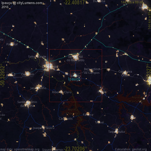
Analysis of Ipauçu night lights 2016
Square area 10x10 km:
 1.59%
1.59%90-99
1.98%80-89
0.79%70-79
2.38%60-69
1.59%50-59
0.6%40-49
0.2%30-39
2.98%20-29
1.59%10-19
0.2%0-9
86.11%Square area 50x50 km:
0.54%90-99
0.65%80-89
0.33%70-79
0.84%60-69
1.02%50-59
0.61%40-49
0.51%30-39
0.68%20-29
0.82%10-19
3.13%0-9
90.89%Clear (daylight) street map image can be seen on geolist.org.
Map coordinates:
22° 24' 29.4" South, 50° 19' 46.3" West
23° 3' 24" South, 49° 37' 35" West
23° 42' 7.4" South, 48° 55' 23.8" West
Some cities around Ipauçu sort by population:
• Ourinhos
26.4 km =16.4 mi,  289°
289°
• Santa Cruz do Rio Pardo
17.6 km =10.9 mi,  357°
357°
• Jacarezinho
36.9 km =22.9 mi,  251°
251°
• Piraju
29.1 km =18.1 mi,  121°
121°
• Cambará
45.8 km =28.5 mi,  271°
271°
• Fartura
38.7 km =24 mi,  162°
162°
• Chavantes
8.7 km =5.4 mi,  283°
283°
• Bernardino de Campos
16.3 km =10.1 mi,  72°
72°
3461143 (p: 10,833)
Sources (retrieved 2019-11-25):
» Earth at Night: Flat Maps 2012, 2016