Ipaba night lights from space
Night Light of Ipaba (Minas Gerais) from space (Brazil) Src. Average luminocity for 10x10km area is 8.6529% and for 50x50km: 10.3127%.
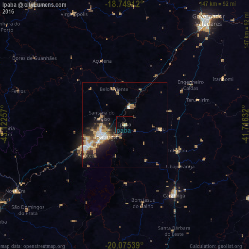
Analysis of Ipaba night lights 2016
Square area 10x10 km:
 0.62%
0.62%90-99
0.21%80-89
0.62%70-79
1.65%60-69
1.86%50-59
0.62%40-49
0.62%30-39
1.65%20-29
0%10-19
5.99%0-9
86.16%Square area 50x50 km:
1.25%90-99
1.21%80-89
1.79%70-79
2.91%60-69
0.91%50-59
0.91%40-49
1.62%30-39
1.29%20-29
2.44%10-19
4.44%0-9
81.24%Clear (daylight) street map image can be seen on geolist.org.
Map coordinates:
18° 44' 56.8" South, 43° 7' 21.3" West
19° 24' 49" South, 42° 25' 10" West
20° 4' 31.4" South, 41° 42' 58.8" West
Some cities around Ipaba sort by population:
• Ipatinga
13.7 km =8.5 mi,  243°
243°
• Coronel Fabriciano
24.9 km =15.5 mi, 242°
• Timóteo
30.5 km =19 mi,  232°
232°
• Santana do Paraíso
16.6 km =10.3 mi,  289°
289°
• Belo Oriente
22.6 km =14 mi,  342°
342°
• Açucena
40.1 km =24.9 mi, 340°
• Inhapim
34.8 km =21.6 mi,  115°
115°
• Bom Jesus do Galho
47.4 km =29.5 mi,  166°
166°
3461153 (p: 15,970)
Sources (retrieved 2019-11-25):
» Earth at Night: Flat Maps 2012, 2016