Inhapim night lights from space
Night Light of Inhapim (Minas Gerais) from space (Brazil) Src. Average luminocity for 10x10km area is 9.6322% and for 50x50km: 2.2731%.
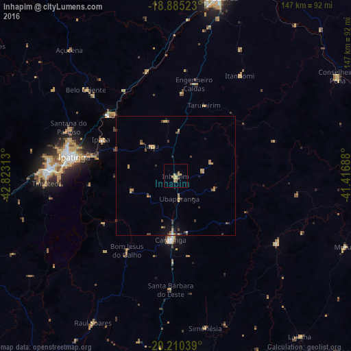
Analysis of Inhapim night lights 2016
Square area 10x10 km:
 0%
0%90-99
0%80-89
4.96%70-79
1.65%60-69
2.27%50-59
0.21%40-49
0%30-39
1.65%20-29
0.83%10-19
0%0-9
88.43%Square area 50x50 km:
0.03%90-99
0.03%80-89
0.55%70-79
0.6%60-69
0.33%50-59
0.2%40-49
0.62%30-39
0.37%20-29
0.24%10-19
0.68%0-9
96.34%Clear (daylight) street map image can be seen on geolist.org.
Map coordinates:
18° 53' 6.8" South, 42° 49' 23.3" West
19° 32' 57" South, 42° 7' 12" West
20° 12' 37.4" South, 41° 25' 0.8" West
Some cities around Inhapim sort by population:
• Ipatinga
44.6 km =27.7 mi,  281°
281°
• Coronel Fabriciano
53.4 km =33.2 mi,  273°
273°
• Timóteo
55.6 km =34.5 mi, 266°
• Caratinga
26.8 km =16.7 mi,  184°
184°
• Santana do Paraíso
51.4 km =31.9 mi,  293°
293°
• Belo Oriente
52.9 km =32.9 mi,  313°
313°
• Ipaba
34.8 km =21.6 mi,  295°
295°
• Bom Jesus do Galho
37.3 km =23.2 mi,  213°
213°
3461214 (p: 13,593)
Sources (retrieved 2019-11-25):
» Earth at Night: Flat Maps 2012, 2016