Belo Oriente night lights from space
Night Light of Belo Oriente (Minas Gerais) from space (Brazil) Src. Average luminocity for 10x10km area is 8.2684% and for 50x50km: 3.4584%.
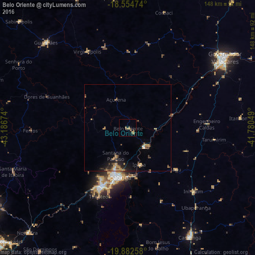
Analysis of Belo Oriente night lights 2016
Square area 10x10 km:
 0%
0%90-99
0%80-89
3.03%70-79
3.46%60-69
0.43%50-59
0.22%40-49
3.03%30-39
0.22%20-29
0%10-19
0.87%0-9
88.74%Square area 50x50 km:
0.14%90-99
0.12%80-89
0.52%70-79
1.04%60-69
0.47%50-59
0.38%40-49
0.75%30-39
0.43%20-29
0.87%10-19
1.97%0-9
93.33%Clear (daylight) street map image can be seen on geolist.org.
Map coordinates:
18° 33' 17.1" South, 43° 11' 12.3" West
19° 13' 12" South, 42° 29' 1" West
19° 52' 57.3" South, 41° 46' 49.8" West
Some cities around Belo Oriente sort by population:
• Ipatinga
28.2 km =17.5 mi,  191°
191°
• Coronel Fabriciano
36.5 km =22.7 mi,  204°
204°
• Timóteo
43.8 km =27.2 mi, 203°
• Santana do Paraíso
18.3 km =11.4 mi,  209°
209°
• Guanhães
68.4 km =42.5 mi,  316°
316°
• Ipaba
22.6 km =14 mi,  162°
162°
• Açucena
17.6 km =10.9 mi,  338°
338°
• Inhapim
52.9 km =32.9 mi,  133°
133°
3470117 (p: 18,470)
Sources (retrieved 2019-11-25):
» Earth at Night: Flat Maps 2012, 2016