Açucena night lights from space
Night Light of Açucena (Minas Gerais) from space (Brazil) Src. Average luminocity for 10x10km area is 1.5433% and for 50x50km: 0.7762%.
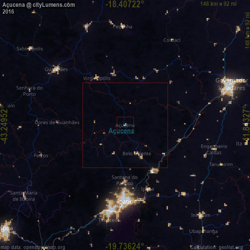
Analysis of Açucena night lights 2016
Square area 10x10 km:
 0%
0%90-99
0%80-89
0%70-79
0%60-69
0.65%50-59
1.52%40-49
0.43%30-39
0%20-29
0%10-19
0%0-9
97.4%Square area 50x50 km:
0%90-99
0%80-89
0.2%70-79
0.28%60-69
0.11%50-59
0.09%40-49
0.23%30-39
0.01%20-29
0.08%10-19
0.08%0-9
98.92%Clear (daylight) street map image can be seen on geolist.org.
Map coordinates:
18° 24' 26" South, 43° 14' 58.3" West
19° 4' 23" South, 42° 32' 47" West
19° 44' 10.5" South, 41° 50' 35.8" West
Some cities around Açucena sort by population:
• Ipatinga
44 km =27.3 mi,  178°
178°
• Coronel Fabriciano
50.3 km =31.3 mi,  189°
189°
• Timóteo
57.5 km =35.7 mi, 190°
• Santana do Paraíso
32.4 km =20.1 mi, 184°
• Guanhães
52.4 km =32.6 mi,  309°
309°
• Belo Oriente
17.6 km =10.9 mi,  158°
158°
• Ipaba
40.1 km =24.9 mi, 160°
• Peçanha
58.3 km =36.2 mi,  358°
358°
3473183 (p: 14,505)
Sources (retrieved 2019-11-25):
» Earth at Night: Flat Maps 2012, 2016