Guaraniaçu night lights from space
Night Light of Guaraniaçu (Paraná) from space (Brazil) Src. Average luminocity for 10x10km area is 5.6818% and for 50x50km: 0.5565%.
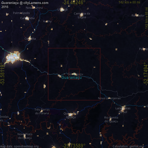
Analysis of Guaraniaçu night lights 2016
Square area 10x10 km:
 0.38%
0.38%90-99
0.38%80-89
0.76%70-79
0.57%60-69
3.03%50-59
0.19%40-49
1.7%30-39
0.57%20-29
0%10-19
0%0-9
92.42%Square area 50x50 km:
0.05%90-99
0.05%80-89
0.08%70-79
0.04%60-69
0.19%50-59
0.11%40-49
0.16%30-39
0.06%20-29
0.06%10-19
0%0-9
99.21%Clear (daylight) street map image can be seen on geolist.org.
Map coordinates:
24° 27' 44.9" South, 53° 34' 52.3" West
25° 6' 3" South, 52° 52' 41" West
25° 44' 9.2" South, 52° 10' 29.8" West
Some cities around Guaraniaçu sort by population:
• Cascavel
60.3 km =37.5 mi,  285°
285°
• Toledo
97.3 km =60.5 mi,  296°
296°
• Dois Vizinhos
72.6 km =45.1 mi,  194°
194°
• Laranjeiras do Sul
57.6 km =35.8 mi,  126°
126°
• Coronel Vivida
102.6 km =63.8 mi,  162°
162°
• Chopinzinho
91.2 km =56.7 mi, 157°
• Corbélia
54.7 km =34 mi,  307°
307°
• Realeza
99.2 km =61.6 mi,  221°
221°
3461892 (p: 7,781)
Sources (retrieved 2019-11-25):
» Earth at Night: Flat Maps 2012, 2016