Coronel Vivida night lights from space
Night Light of Coronel Vivida (Paraná) from space (Brazil) Src. Average luminocity for 10x10km area is 13.3571% and for 50x50km: 2.0523%.
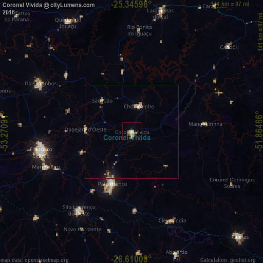
Analysis of Coronel Vivida night lights 2016
Square area 10x10 km:
 0.79%
0.79%90-99
0.79%80-89
2.78%70-79
3.17%60-69
3.37%50-59
1.59%40-49
1.79%30-39
0.79%20-29
0.79%10-19
0.79%0-9
83.33%Square area 50x50 km:
0.06%90-99
0.14%80-89
0.35%70-79
0.44%60-69
0.51%50-59
0.22%40-49
0.19%30-39
0.28%20-29
0.3%10-19
0.76%0-9
96.74%Clear (daylight) street map image can be seen on geolist.org.
Map coordinates:
25° 20' 45.5" South, 53° 16' 15.3" West
25° 58' 47" South, 52° 34' 4" West
26° 36' 36.3" South, 51° 51' 52.8" West
Some cities around Coronel Vivida sort by population:
• Pato Branco
29.5 km =18.3 mi,  200°
200°
• Francisco Beltrão
50 km =31.1 mi,  256°
256°
• Palmas
80.4 km =50 mi,  134°
134°
• Dois Vizinhos
56.1 km =34.9 mi,  299°
299°
• Laranjeiras do Sul
65.4 km =40.6 mi,  13°
13°
• São Lourenço do Oeste
50.8 km =31.6 mi,  213°
213°
• Clevelândia
47.3 km =29.4 mi,  168°
168°
• Chopinzinho
14.5 km =9 mi,  17°
17°
3465459 (p: 15,841)
Sources (retrieved 2019-11-25):
» Earth at Night: Flat Maps 2012, 2016