São Lourenço do Oeste night lights from space
Night Light of São Lourenço do Oeste (Santa Catarina) from space (Brazil) Src. Average luminocity for 10x10km area is 18.9337% and for 50x50km: 4.3883%.
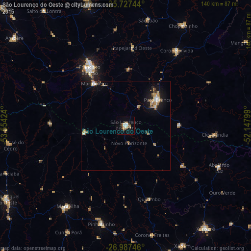
Analysis of São Lourenço do Oeste night lights 2016
Square area 10x10 km:
 2.46%
2.46%90-99
2.84%80-89
4.17%70-79
1.7%60-69
3.79%50-59
1.14%40-49
1.33%30-39
1.7%20-29
0.57%10-19
8.52%0-9
71.78%Square area 50x50 km:
0.43%90-99
0.56%80-89
0.66%70-79
0.72%60-69
0.8%50-59
0.48%40-49
0.29%30-39
0.44%20-29
0.55%10-19
3.25%0-9
91.81%Clear (daylight) street map image can be seen on geolist.org.
Map coordinates:
25° 43' 38.8" South, 53° 33' 15.3" West
26° 21' 33" South, 52° 51' 4" West
26° 59' 14.9" South, 52° 8' 52.8" West
Some cities around São Lourenço do Oeste sort by population:
• Pato Branco
23.1 km =14.4 mi,  51°
51°
• Francisco Beltrão
37 km =23 mi,  326°
326°
• Xanxerê
72.7 km =45.2 mi,  142°
142°
• Dois Vizinhos
72.5 km =45 mi,  343°
343°
• Coronel Vivida
50.8 km =31.6 mi,  33°
33°
• Clevelândia
38.1 km =23.7 mi,  96°
96°
• Ampére
79.3 km =49.3 mi,  308°
308°
• Chopinzinho
64.8 km =40.3 mi, 30°
3448597 (p: 14,871)
Sources (retrieved 2019-11-25):
» Earth at Night: Flat Maps 2012, 2016