Coromandel night lights from space
Night Light of Coromandel (Minas Gerais) from space (Brazil) Src. Average luminocity for 10x10km area is 14.2479% and for 50x50km: 0.7731%.
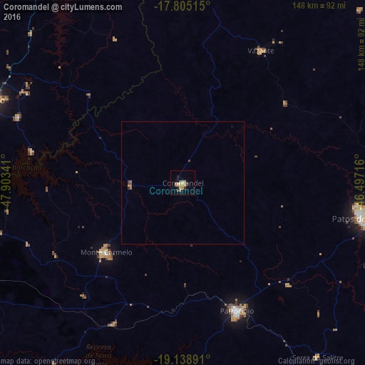

Analysis of Coromandel night lights 2016
Square area 10x10 km:
 0%
0%90-99
1.03%80-89
2.27%70-79
5.58%60-69
2.69%50-59
1.03%40-49
1.45%30-39
1.65%20-29
1.86%10-19
2.69%0-9
79.75%Square area 50x50 km:
0%90-99
0.04%80-89
0.09%70-79
0.28%60-69
0.14%50-59
0.08%40-49
0.18%30-39
0.08%20-29
0.1%10-19
0.14%0-9
98.88%Clear (daylight) street map image can be seen on geolist.org.
Map coordinates:
17° 48' 18.5" South, 47° 54' 12.3" West
18° 28' 24" South, 47° 12' 1" West
19° 8' 20.1" South, 46° 29' 49.8" West
Some cities around Coromandel sort by population:
• Patos de Minas
72.9 km =45.3 mi,  99°
99°
• Araguari
105.8 km =65.7 mi,  259°
259°
• Patrocínio
56.7 km =35.2 mi,  157°
157°
• Catalão
85.9 km =53.4 mi,  293°
293°
• Monte Carmelo
42.1 km =26.2 mi,  228°
228°
• Vazante
62.3 km =38.7 mi,  29°
29°
• Presidente Olegário
82.7 km =51.4 mi,  85°
85°
• Lagoa Formosa
90.2 km =56 mi,  112°
112°
3465487 (p: 22,647)
Sources (retrieved 2019-11-25):
» Earth at Night: Flat Maps 2012, 2016