Lagoa Formosa night lights from space
Night Light of Lagoa Formosa (Minas Gerais) from space (Brazil) Src. Average luminocity for 10x10km area is 8.7645% and for 50x50km: 3.7334%.
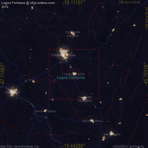
Analysis of Lagoa Formosa night lights 2016
Square area 10x10 km:
 0.21%
0.21%90-99
0.62%80-89
0%70-79
1.65%60-69
5.58%50-59
1.86%40-49
0.83%30-39
0%20-29
0.21%10-19
0.62%0-9
88.43%Square area 50x50 km:
0.39%90-99
0.67%80-89
0.4%70-79
0.82%60-69
0.58%50-59
0.37%40-49
0.47%30-39
0.44%20-29
0.51%10-19
2.45%0-9
92.89%Clear (daylight) street map image can be seen on geolist.org.
Map coordinates:
18° 6' 41.8" South, 47° 6' 38.3" West
18° 46' 43" South, 46° 24' 27" West
19° 26' 34.7" South, 45° 42' 15.8" West
Some cities around Lagoa Formosa sort by population:
• Patos de Minas
25.1 km =15.6 mi,  332°
332°
• Patrocínio
64.2 km =39.9 mi,  253°
253°
• São Gotardo
70.2 km =43.6 mi,  147°
147°
• Carmo do Paranaíba
26.5 km =16.5 mi,  158°
158°
• Coromandel
90.2 km =56 mi,  292°
292°
• Ibiá
79 km =49.1 mi,  190°
190°
• Vazante
102.6 km =63.8 mi, 329°
• Presidente Olegário
40.1 km =24.9 mi,  358°
358°
3459181 (p: 11,822)
Sources (retrieved 2019-11-25):
» Earth at Night: Flat Maps 2012, 2016