Cantagalo night lights from space
Night Light of Cantagalo (Rio de Janeiro) from space (Brazil) Src. Average luminocity for 10x10km area is 18.9464% and for 50x50km: 4.0285%.
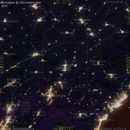
Analysis of Cantagalo night lights 2016
Square area 10x10 km:
 0.79%
0.79%90-99
0.99%80-89
4.37%70-79
4.56%60-69
1.59%50-59
2.58%40-49
2.98%30-39
1.98%20-29
0.99%10-19
17.66%0-9
61.51%Square area 50x50 km:
0.1%90-99
0.26%80-89
0.61%70-79
0.95%60-69
0.62%50-59
0.69%40-49
0.65%30-39
0.56%20-29
0.38%10-19
1.88%0-9
93.3%Clear (daylight) street map image can be seen on geolist.org.
Map coordinates:
21° 19' 39.4" South, 43° 4' 16.3" West
21° 58' 52" South, 42° 22' 5" West
22° 37' 53.8" South, 41° 39' 53.8" West
Some cities around Cantagalo sort by population:
• Nova Friburgo
37.4 km =23.2 mi,  206°
206°
• Além Paraíba
36.2 km =22.5 mi,  286°
286°
• Santo Antônio de Pádua
52.8 km =32.8 mi,  21°
21°
• Itaocara
45.9 km =28.5 mi,  40°
40°
• Cordeiro
5.3 km =3.3 mi,  171°
171°
• Sapucaia
56.4 km =35 mi,  268°
268°
• Carmo
25.4 km =15.8 mi,  282°
282°
• Recreio
51.8 km =32.2 mi,  348°
348°
3467445 (p: 14,019)
Sources (retrieved 2019-11-25):
» Earth at Night: Flat Maps 2012, 2016