Sapucaia night lights from space
Night Light of Sapucaia (Rio de Janeiro) from space (Brazil) Src. Average luminocity for 10x10km area is 5.2421% and for 50x50km: 3.0118%.
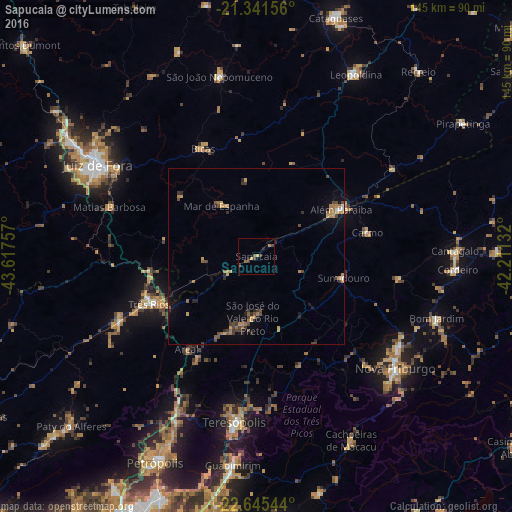
Analysis of Sapucaia night lights 2016
Square area 10x10 km:
 0%
0%90-99
0%80-89
0.4%70-79
1.19%60-69
0.79%50-59
1.59%40-49
2.58%30-39
1.39%20-29
0.4%10-19
1.19%0-9
90.48%Square area 50x50 km:
0.1%90-99
0.06%80-89
0.17%70-79
0.76%60-69
0.65%50-59
0.44%40-49
0.9%30-39
0.52%20-29
0.74%10-19
0.81%0-9
94.84%Clear (daylight) street map image can be seen on geolist.org.
Map coordinates:
21° 20' 29.6" South, 43° 37' 3.3" West
21° 59' 42" South, 42° 54' 52" West
22° 38' 43.6" South, 42° 12' 40.8" West
Some cities around Sapucaia sort by population:
• Três Rios
33.2 km =20.6 mi,  245°
245°
• Paraíba do Sul
43.1 km =26.8 mi, 245°
• Além Paraíba
24.7 km =15.3 mi,  61°
61°
• Bicas
33.5 km =20.8 mi,  333°
333°
• Matias Barbosa
44.1 km =27.4 mi,  288°
288°
• Carmo
32.3 km =20.1 mi,  77°
77°
• Areal
32.8 km =20.4 mi,  216°
216°
• Mar de Espanha
17.3 km =10.7 mi, 325°
3448033 (p: 12,329)
Sources (retrieved 2019-11-25):
» Earth at Night: Flat Maps 2012, 2016