Itaocara night lights from space
Night Light of Itaocara (Rio de Janeiro) from space (Brazil) Src. Average luminocity for 10x10km area is 18.3598% and for 50x50km: 3.1222%.
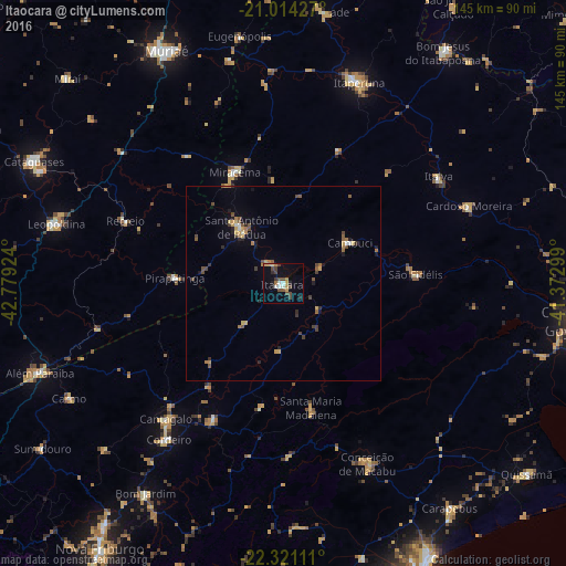
Analysis of Itaocara night lights 2016
Square area 10x10 km:
 1.89%
1.89%90-99
1.89%80-89
1.89%70-79
2.65%60-69
2.65%50-59
0.95%40-49
6.63%30-39
2.46%20-29
2.08%10-19
6.63%0-9
70.27%Square area 50x50 km:
0.14%90-99
0.2%80-89
0.32%70-79
0.58%60-69
0.47%50-59
0.49%40-49
0.86%30-39
0.42%20-29
0.49%10-19
0.93%0-9
95.1%Clear (daylight) street map image can be seen on geolist.org.
Map coordinates:
21° 0' 51.4" South, 42° 46' 45.3" West
21° 40' 9" South, 42° 4' 34" West
22° 19' 16" South, 41° 22' 22.8" West
Some cities around Itaocara sort by population:
• Itaperuna
55.2 km =34.3 mi,  20°
20°
• Santo Antônio de Pádua
18 km =11.2 mi,  323°
323°
• São Fidélis
34.1 km =21.2 mi,  85°
85°
• Miracema
31.2 km =19.4 mi,  336°
336°
• Cordeiro
49.6 km =30.8 mi,  216°
216°
• Cantagalo
45.9 km =28.5 mi, 220°
• Cambuci
20 km =12.4 mi,  58°
58°
• Recreio
43.7 km =27.2 mi,  291°
291°
3460774 (p: 16,762)
Sources (retrieved 2019-11-25):
» Earth at Night: Flat Maps 2012, 2016