Cambebba night lights from space
Night Light of Cambebba (Ceará) from space (Brazil) Src. Average luminocity for 10x10km area is 48.6169% and for 50x50km: 20.9014%.
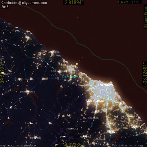
Analysis of Cambebba night lights 2016
Square area 10x10 km:
 3.68%
3.68%90-99
8.44%80-89
7.58%70-79
2.38%60-69
4.76%50-59
16.88%40-49
12.12%30-39
12.34%20-29
22.29%10-19
9.52%0-9
0%Square area 50x50 km:
2.68%90-99
4.83%80-89
2.47%70-79
2.15%60-69
2.4%50-59
3.41%40-49
3.59%30-39
3.22%20-29
5.75%10-19
10.19%0-9
59.33%Clear (daylight) street map image can be seen on geolist.org.
Map coordinates:
2° 55' 8.2" South, 39° 31' 56.1" West
3° 37' 15.3" South, 38° 49' 44.9" West
4° 19' 20.5" South, 38° 7' 33.6" West
Some cities around Cambebba sort by population:
• Fortaleza
33.5 km =20.8 mi,  108°
108°
• Caucaia
23.4 km =14.5 mi,  123°
123°
• Maracanaú
36.3 km =22.6 mi,  141°
141°
• Pacatuba
46.6 km =29 mi,  150°
150°
• São Gonçalo do Amarante
15.5 km =9.6 mi,  275°
275°
• Paracuru
32.4 km =20.1 mi,  316°
316°
• Paraipaba
40.8 km =25.4 mi,  299°
299°
• Jardim
30.7 km =19.1 mi, 304°
6693804 (p: 0)
Sources (retrieved 2019-11-25):
» Earth at Night: Flat Maps 2012, 2016