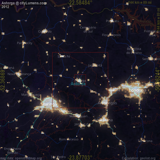
Astorga night lights from space
Night Light of Astorga (Paraná) from space (Brazil) Src. Average luminocity for 10x10km area is 15.5227% and for 50x50km: 8.4648%.

Analysis of Astorga night lights 2016
Square area 10x10 km:
 2.08%
2.08%90-99
0.95%80-89
0.95%70-79
5.3%60-69
2.08%50-59
1.52%40-49
2.27%30-39
0.76%20-29
0%10-19
3.03%0-9
81.06%Square area 50x50 km:
1.48%90-99
1.33%80-89
0.71%70-79
1.55%60-69
1.08%50-59
0.78%40-49
1.34%30-39
0.94%20-29
1.99%10-19
3.42%0-9
85.37%Clear (daylight) street map image can be seen on geolist.org.
Map coordinates:
22° 35' 5.4" South, 52° 22' 7.3" West
23° 13' 57" South, 51° 39' 56" West
23° 52' 37.3" South, 50° 57' 44.8" West
Some cities around Astorga sort by population:
• Maringá
35.2 km =21.9 mi,  232°
232°
• Apucarana
41.1 km =25.5 mi,  149°
149°
• Arapongas
32.2 km =20 mi,  130°
130°
• Cambé
39.9 km =24.8 mi,  96°
96°
• Sarandi
31.7 km =19.7 mi,  222°
222°
• Rolândia
31.5 km =19.6 mi,  105°
105°
• Mandaguari
35 km =21.7 mi,  180°
180°
• Marialva
30.9 km =19.2 mi,  204°
204°
3471368 (p: 20,128)
Sources (retrieved 2019-11-25):
» Earth at Night: Flat Maps 2012, 2016