Ampére night lights from space
Night Light of Ampére (Paraná) from space (Brazil) Src. Average luminocity for 10x10km area is 13.858% and for 50x50km: 2.2014%.
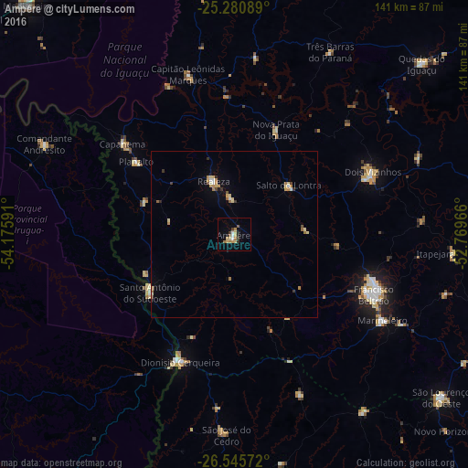
Analysis of Ampére night lights 2016
Square area 10x10 km:
 0.95%
0.95%90-99
1.33%80-89
3.6%70-79
2.46%60-69
2.27%50-59
1.52%40-49
0.57%30-39
1.7%20-29
1.7%10-19
1.7%0-9
82.2%Square area 50x50 km:
0.12%90-99
0.21%80-89
0.53%70-79
0.42%60-69
0.32%50-59
0.24%40-49
0.14%30-39
0.29%20-29
0.14%10-19
0.25%0-9
97.34%Clear (daylight) street map image can be seen on geolist.org.
Map coordinates:
25° 16' 51.2" South, 54° 10' 33.3" West
25° 54' 54" South, 53° 28' 22" West
26° 32' 44.6" South, 52° 46' 10.8" West
Some cities around Ampére sort by population:
• Pato Branco
87.4 km =54.3 mi,  113°
113°
• Francisco Beltrão
45.7 km =28.4 mi, 113°
• Dois Vizinhos
46.2 km =28.7 mi,  64°
64°
• Coronel Vivida
90.8 km =56.4 mi,  94°
94°
• São Lourenço do Oeste
79.3 km =49.3 mi,  128°
128°
• Santo Antônio do Sudoeste
30.8 km =19.1 mi,  235°
235°
• Bernardo de Irigoyen, AR
41.6 km =25.8 mi,  204°
204°
• Realeza
17.3 km =10.7 mi,  339°
339°
3472304 (p: 14,274)
Sources (retrieved 2019-11-25):
» Earth at Night: Flat Maps 2012, 2016