Bernardo de Irigoyen night lights from space
Night Light of Bernardo de Irigoyen (Misiones) from space (Argentina) Src. Average luminocity for 10x10km area is 19.4802% and for 50x50km: 1.9131%.
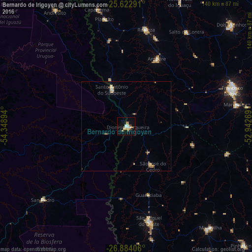
Analysis of Bernardo de Irigoyen night lights 2016
Square area 10x10 km:
 2.38%
2.38%90-99
2.78%80-89
3.97%70-79
3.57%60-69
3.17%50-59
0.79%40-49
0.99%30-39
1.59%20-29
0.99%10-19
7.54%0-9
72.22%Square area 50x50 km:
0.12%90-99
0.19%80-89
0.53%70-79
0.28%60-69
0.36%50-59
0.11%40-49
0.18%30-39
0.21%20-29
0.11%10-19
0.4%0-9
97.51%Clear (daylight) street map image can be seen on geolist.org.
Map coordinates:
25° 37' 22.5" South, 54° 20' 56.2" West
26° 15' 18.7" South, 53° 38' 44.9" West
26° 53' 2.6" South, 52° 56' 33.7" West
Some cities around Bernardo de Irigoyen sort by population:
• Francisco Beltrão, BR
62.1 km =38.6 mi,  71°
71°
• San Vicente
63 km =39.1 mi,  230°
230°
• San Pedro
61.5 km =38.2 mi, 228°
• Dois Vizinhos, BR
82.6 km =51.3 mi,  45°
45°
• São Lourenço do Oeste, BR
80 km =49.7 mi,  98°
98°
• Ampére, BR
41.6 km =25.8 mi,  24°
24°
• Santo Antônio do Sudoeste, BR
21.7 km =13.5 mi,  338°
338°
• Realeza, BR
55.2 km =34.3 mi,  11°
11°
3436030 (p: 10,889)
Sources (retrieved 2019-11-25):
» Earth at Night: Flat Maps 2012, 2016