Santo Antônio do Sudoeste night lights from space
Night Light of Santo Antônio do Sudoeste (Paraná) from space (Brazil) Src. Average luminocity for 10x10km area is 12.8452% and for 50x50km: 1.9331%.
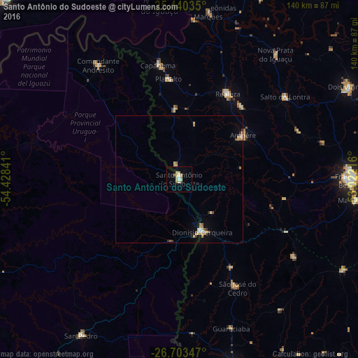
Analysis of Santo Antônio do Sudoeste night lights 2016
Square area 10x10 km:
 0.79%
0.79%90-99
1.79%80-89
4.96%70-79
1.19%60-69
1.79%50-59
0.6%40-49
0.6%30-39
0.2%20-29
0.79%10-19
1.19%0-9
86.11%Square area 50x50 km:
0.15%90-99
0.22%80-89
0.58%70-79
0.24%60-69
0.31%50-59
0.12%40-49
0.12%30-39
0.16%20-29
0.09%10-19
0.42%0-9
97.59%Clear (daylight) street map image can be seen on geolist.org.
Map coordinates:
25° 26' 25.3" South, 54° 25' 42.3" West
26° 4' 25" South, 53° 43' 31" West
26° 42' 12.5" South, 53° 1' 19.8" West
Some cities around Santo Antônio do Sudoeste sort by population:
• Francisco Beltrão
66.9 km =41.6 mi,  90°
90°
• San Vicente, AR
72.8 km =45.2 mi,  213°
213°
• San Pedro, AR
71.9 km =44.7 mi, 212°
• Dois Vizinhos
76.8 km =47.7 mi,  60°
60°
• Wanda, AR
84.5 km =52.5 mi,  277°
277°
• Ampére
30.8 km =19.1 mi, 55°
• Bernardo de Irigoyen, AR
21.7 km =13.5 mi,  158°
158°
• Realeza
39 km =24.2 mi,  29°
29°
3449479 (p: 11,723)
Sources (retrieved 2019-11-25):
» Earth at Night: Flat Maps 2012, 2016