Alterosa night lights from space
Night Light of Alterosa (Minas Gerais) from space (Brazil) Src. Average luminocity for 10x10km area is 3.9742% and for 50x50km: 2.2228%.
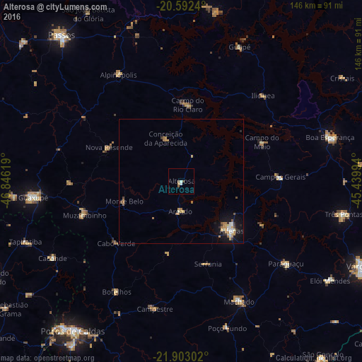
Analysis of Alterosa night lights 2016
Square area 10x10 km:
 0.6%
0.6%90-99
0.99%80-89
0%70-79
0.79%60-69
0%50-59
1.79%40-49
0.6%30-39
0%20-29
0%10-19
0%0-9
95.24%Square area 50x50 km:
0.22%90-99
0.3%80-89
0.2%70-79
0.55%60-69
0.52%50-59
0.17%40-49
0.17%30-39
0.21%20-29
0.15%10-19
1.83%0-9
95.67%Clear (daylight) street map image can be seen on geolist.org.
Map coordinates:
20° 35' 32.6" South, 46° 50' 46.3" West
21° 14' 57" South, 46° 8' 35" West
21° 54' 10.9" South, 45° 26' 23.8" West
Some cities around Alterosa sort by population:
• Alfenas
28.5 km =17.7 mi,  134°
134°
• Campos Gerais
39.9 km =24.8 mi,  87°
87°
• Muzambinho
42 km =26.1 mi,  250°
250°
• Carmo do Rio Claro
30.9 km =19.2 mi,  4°
4°
• Alpinópolis
49.8 km =30.9 mi,  329°
329°
• Campestre
52.5 km =32.6 mi,  191°
191°
• Botelhos
50 km =31.1 mi,  211°
211°
• Areado
12.2 km =7.6 mi,  181°
181°
3472487 (p: 9,277)
Sources (retrieved 2019-11-25):
» Earth at Night: Flat Maps 2012, 2016