Muzambinho night lights from space
Night Light of Muzambinho (Minas Gerais) from space (Brazil) Src. Average luminocity for 10x10km area is 9.2121% and for 50x50km: 2.5401%.
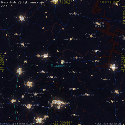
Analysis of Muzambinho night lights 2016
Square area 10x10 km:
 0%
0%90-99
0.76%80-89
2.27%70-79
2.65%60-69
1.14%50-59
1.89%40-49
1.7%30-39
0.95%20-29
0%10-19
0%0-9
88.64%Square area 50x50 km:
0.18%90-99
0.28%80-89
0.34%70-79
0.49%60-69
0.53%50-59
0.4%40-49
0.31%30-39
0.27%20-29
0.26%10-19
1.44%0-9
95.51%Clear (daylight) street map image can be seen on geolist.org.
Map coordinates:
20° 43' 10.6" South, 47° 13' 43.3" West
21° 22' 33" South, 46° 31' 32" West
22° 1' 44.8" South, 45° 49' 20.8" West
Some cities around Muzambinho sort by population:
• Poços de Caldas
46 km =28.6 mi,  184°
184°
• Guaxupé
20.9 km =13 mi,  292°
292°
• São José do Rio Pardo
44.8 km =27.8 mi,  236°
236°
• Guaranésia
29.9 km =18.6 mi, 286°
• Caconde
21 km =13 mi,  215°
215°
• Botelhos
31.7 km =19.7 mi,  154°
154°
• Areado
39.4 km =24.5 mi,  87°
87°
• Alterosa
42 km =26.1 mi,  70°
70°
3456412 (p: 16,253)
Sources (retrieved 2019-11-25):
» Earth at Night: Flat Maps 2012, 2016