Vianópolis night lights from space
Night Light of Vianópolis (Goiás) from space (Brazil) Src. Average luminocity for 10x10km area is 8.9675% and for 50x50km: 0.9821%.
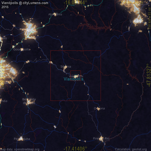
Analysis of Vianópolis night lights 2016
Square area 10x10 km:
 0.43%
0.43%90-99
0.43%80-89
0%70-79
3.68%60-69
3.25%50-59
0.87%40-49
1.73%30-39
0%20-29
1.73%10-19
0%0-9
87.88%Square area 50x50 km:
0.02%90-99
0.02%80-89
0.1%70-79
0.3%60-69
0.29%50-59
0.14%40-49
0.27%30-39
0.08%20-29
0.15%10-19
0.03%0-9
98.6%Clear (daylight) street map image can be seen on geolist.org.
Map coordinates:
16° 4' 2.8" South, 49° 13' 10.3" West
16° 44' 31" South, 48° 30' 59" West
17° 24' 50.6" South, 47° 48' 47.8" West
Some cities around Vianópolis sort by population:
• Anápolis
65.5 km =40.7 mi,  314°
314°
• Senador Canedo
61.5 km =38.2 mi,  273°
273°
• Pires do Rio
66.9 km =41.6 mi,  157°
157°
• Bela Vista de Goiás
53.1 km =33 mi,  241°
241°
• Silvânia
13.4 km =8.3 mi, 313°
• Goianápolis
59.9 km =37.2 mi,  295°
295°
• Orizona
39.8 km =24.7 mi,  143°
143°
• Abadiânia
63.2 km =39.3 mi,  341°
341°
3445148 (p: 7,807)
Sources (retrieved 2019-11-25):
» Earth at Night: Flat Maps 2012, 2016