Portachuelo night lights from space
Night Light of Portachuelo (Santa Cruz) from space (Bolivia) Src. Average luminocity for 10x10km area is 6.8967% and for 50x50km: 4.9694%.
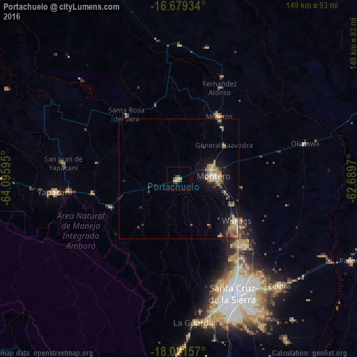
Analysis of Portachuelo night lights 2016
Square area 10x10 km:
 0.21%
0.21%90-99
0.62%80-89
0.83%70-79
2.27%60-69
1.03%50-59
0.83%40-49
0.21%30-39
3.31%20-29
1.03%10-19
0.41%0-9
89.26%Square area 50x50 km:
0.26%90-99
0.28%80-89
0.97%70-79
0.8%60-69
1.27%50-59
0.63%40-49
0.56%30-39
0.77%20-29
0.71%10-19
4.18%0-9
89.57%Clear (daylight) street map image can be seen on geolist.org.
Map coordinates:
16° 40' 45.6" South, 64° 5' 45.4" West
17° 21' 6" South, 63° 23' 34.2" West
18° 1' 17.7" South, 62° 41' 22.9" West
Some cities around Portachuelo sort by population:
• Santa Cruz de la Sierra
53.3 km =33.1 mi,  155°
155°
• Montero
15.2 km =9.4 mi,  84°
84°
• Warnes
30.1 km =18.7 mi,  127°
127°
• Cotoca
63.2 km =39.3 mi,  144°
144°
• Villa Yapacaní
47.1 km =29.3 mi,  263°
263°
• Mineros
31.1 km =19.3 mi,  33°
33°
• La Bélgica
28.9 km =18 mi, 139°
• Santa Rosa del Sara
34.5 km =21.4 mi,  321°
321°
3907646 (p: 11,485)
Sources (retrieved 2019-11-25):
» Earth at Night: Flat Maps 2012, 2016