Santa Rosa del Sara night lights from space
Night Light of Santa Rosa del Sara (Santa Cruz) from space (Bolivia) Src. Average luminocity for 10x10km area is 2.197% and for 50x50km: 0.283%.
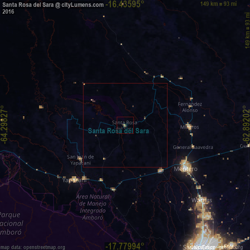
Analysis of Santa Rosa del Sara night lights 2016
Square area 10x10 km:
 0%
0%90-99
0%80-89
0.43%70-79
0.43%60-69
0.43%50-59
0.43%40-49
0.87%30-39
0.65%20-29
1.08%10-19
0%0-9
95.67%Square area 50x50 km:
0%90-99
0%80-89
0.07%70-79
0.06%60-69
0.02%50-59
0.05%40-49
0.06%30-39
0.12%20-29
0.14%10-19
0.04%0-9
99.44%Clear (daylight) street map image can be seen on geolist.org.
Map coordinates:
16° 26' 9.4" South, 64° 17' 53.8" West
17° 6' 33" South, 63° 35' 42.5" West
17° 46' 47.8" South, 62° 53' 31.3" West
Some cities around Santa Rosa del Sara sort by population:
• Montero
44.6 km =27.7 mi,  124°
124°
• Warnes
64.1 km =39.8 mi,  134°
134°
• Cotoca
97.6 km =60.6 mi,  143°
143°
• Villa Yapacaní
41.1 km =25.5 mi,  218°
218°
• Santiago del Torno
100.2 km =62.3 mi,  166°
166°
• Mineros
38.7 km =24 mi,  91°
91°
• Portachuelo
34.5 km =21.4 mi, 141°
• La Bélgica
63.4 km =39.4 mi, 140°
3904729 (p: 5,251)
Sources (retrieved 2019-11-25):
» Earth at Night: Flat Maps 2012, 2016