Retie night lights from space
Night Light of Retie (Flanders) from space (Belgium) Src. Average luminocity for 10x10km area is 15.2437% and for 50x50km: 20.9773%.
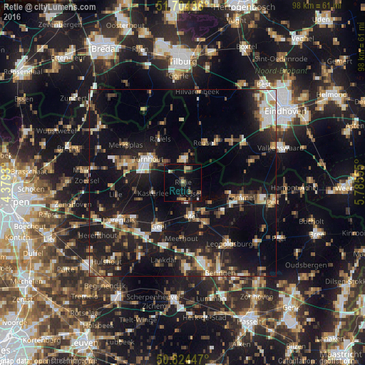
Analysis of Retie night lights 2016
Square area 10x10 km:
100  0.42%
0.42%
90-99 0.7%
80-89 2.8%
70-79 0.56%
60-69 1.4%
50-59 3.5%
40-49 3.08%
30-39 2.24%
20-29 2.94%
10-19 18.63%
0-9 63.73%
0.42%90-99
0.7%80-89
2.8%70-79
0.56%60-69
1.4%50-59
3.5%40-49
3.08%30-39
2.24%20-29
2.94%10-19
18.63%0-9
63.73%Square area 50x50 km:
100 2.38%
90-99 2.92%
80-89 1.94%
70-79 2.34%
60-69 2.32%
50-59 2.99%
40-49 3.42%
30-39 2.94%
20-29 7.01%
10-19 23.34%
0-9 48.4%
2.38%90-99
2.92%80-89
1.94%70-79
2.34%60-69
2.32%50-59
2.99%40-49
3.42%30-39
2.94%20-29
7.01%10-19
23.34%0-9
48.4%Clear (daylight) street map image can be seen on geolist.org.
Map coordinates:
51° 42' 15.7" North, 4° 22' 45.5" East
51° 15' 59.5" North, 5° 4' 56.7" East
50° 49' 28.1" North, 5° 47' 8" East
Some cities around Retie sort by population:
• Turnhout
11.4 km =7.1 mi,  303°
303°
• Mol
8.6 km =5.3 mi,  163°
163°
• Balen
12.5 km =7.8 mi,  150°
150°
• Kasterlee
8.5 km =5.3 mi,  250°
250°
• Oud-Turnhout
9 km =5.6 mi,  310°
310°
• Arendonk
6.2 km =3.9 mi,  0°
0°
• Dessel
3.8 km =2.4 mi,  144°
144°
• Reusel, NL
12.1 km =7.5 mi,  28°
28°
2788138 (p: 10,069)
Sources (retrieved 2019-11-25):
» Earth at Night: Flat Maps 2012, 2016