Arendonk night lights from space
Night Light of Arendonk (Flanders) from space (Belgium) Src. Average luminocity for 10x10km area is 16.1765% and for 50x50km: 19.5588%.
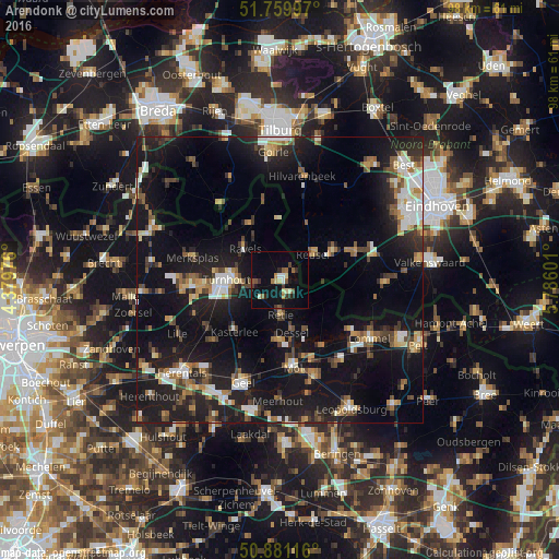
Analysis of Arendonk night lights 2016
Square area 10x10 km:
 0.98%
0.98%90-99
1.4%80-89
3.22%70-79
0.7%60-69
2.1%50-59
2.8%40-49
1.82%30-39
2.24%20-29
2.38%10-19
12.46%0-9
69.89%Square area 50x50 km:
2.33%90-99
2.68%80-89
1.79%70-79
2.04%60-69
2.15%50-59
2.7%40-49
2.8%30-39
2.61%20-29
6.25%10-19
23.23%0-9
51.41%Clear (daylight) street map image can be seen on geolist.org.
Map coordinates:
51° 45' 35.9" North, 4° 22' 47.1" East
51° 19' 21.6" North, 5° 4' 58.4" East
50° 52' 52.2" North, 5° 47' 9.6" East
Some cities around Arendonk sort by population:
• Turnhout
9.6 km =6 mi,  269°
269°
• Kasterlee
12.1 km =7.5 mi,  221°
221°
• Ravels
8.4 km =5.2 mi,  311°
311°
• Oud-Turnhout
6.9 km =4.3 mi, 267°
• Retie
6.2 km =3.9 mi,  180°
180°
• Bladel, NL
10.8 km =6.7 mi,  62°
62°
• Dessel
9.6 km =6 mi,  166°
166°
• Reusel, NL
7.2 km =4.5 mi,  52°
52°
2803083 (p: 12,247)
Sources (retrieved 2019-11-25):
» Earth at Night: Flat Maps 2012, 2016