Leopoldsburg night lights from space
Night Light of Leopoldsburg (Flanders) from space (Belgium) Src. Average luminocity for 10x10km area is 24.0094% and for 50x50km: 24.9137%.
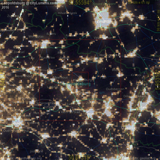
Analysis of Leopoldsburg night lights 2016
Square area 10x10 km:
 1.2%
1.2%90-99
2.14%80-89
2.01%70-79
3.74%60-69
1.34%50-59
4.55%40-49
2.94%30-39
5.48%20-29
13.37%10-19
36.23%0-9
27.01%Square area 50x50 km:
2.86%90-99
3.36%80-89
1.99%70-79
2.7%60-69
3.21%50-59
3.96%40-49
4.5%30-39
4.5%20-29
9.55%10-19
22.34%0-9
41.04%Clear (daylight) street map image can be seen on geolist.org.
Map coordinates:
51° 33' 21.4" North, 4° 32' 48.7" East
51° 7' 0" North, 5° 15' 0" East
50° 40' 23.4" North, 5° 57' 11.2" East
Some cities around Leopoldsburg sort by population:
• Beringen
7.6 km =4.7 mi,  192°
192°
• Mol
12.5 km =7.8 mi,  311°
311°
• Heusden
9.1 km =5.7 mi,  166°
166°
• Houthalen
12.6 km =7.8 mi,  136°
136°
• Helchteren
11.5 km =7.1 mi,  126°
126°
• Balen
8 km =5 mi,  315°
315°
• Tessenderlo
12.6 km =7.8 mi,  243°
243°
• Meerhout
12.1 km =7.5 mi,  278°
278°
2792856 (p: 14,149)
Sources (retrieved 2019-11-25):
» Earth at Night: Flat Maps 2012, 2016