Tessenderlo night lights from space
Night Light of Tessenderlo (Flanders) from space (Belgium) Src. Average luminocity for 10x10km area is 36.139% and for 50x50km: 25.772%.
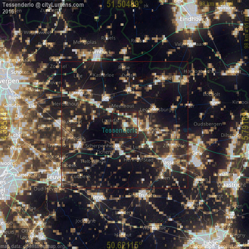
Analysis of Tessenderlo night lights 2016
Square area 10x10 km:
 4.95%
4.95%90-99
5.35%80-89
3.34%70-79
3.88%60-69
4.28%50-59
3.07%40-49
6.02%30-39
7.62%20-29
21.52%10-19
35.43%0-9
4.55%Square area 50x50 km:
2.38%90-99
2.96%80-89
1.82%70-79
2.52%60-69
3.29%50-59
4.06%40-49
5.29%30-39
5.41%20-29
11.85%10-19
29.96%0-9
30.44%Clear (daylight) street map image can be seen on geolist.org.
Map coordinates:
51° 30' 17.6" North, 4° 23' 7.6" East
51° 3' 54.5" North, 5° 5' 18.8" East
50° 37' 16.1" North, 5° 47' 30.1" East
Some cities around Tessenderlo sort by population:
• Beringen
9.8 km =6.1 mi,  100°
100°
• Westerlo
12.4 km =7.7 mi,  283°
283°
• Diest
8.8 km =5.5 mi,  197°
197°
• Balen
12.8 km =8 mi,  26°
26°
• Leopoldsburg
12.6 km =7.8 mi,  63°
63°
• Lummen
11.2 km =7 mi,  140°
140°
• Meerhout
7.5 km =4.7 mi,  354°
354°
• Halen
13.1 km =8.1 mi,  173°
173°
2785612 (p: 16,574)
Sources (retrieved 2019-11-25):
» Earth at Night: Flat Maps 2012, 2016