Duffel night lights from space
Night Light of Duffel (Flanders) from space (Belgium) Src. Average luminocity for 10x10km area is 73.8155% and for 50x50km: 56.6916%.
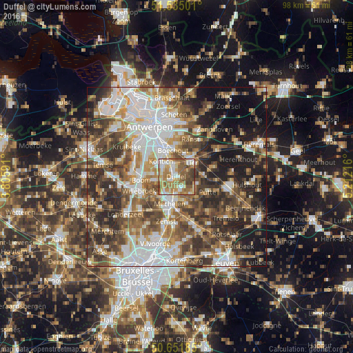
Analysis of Duffel night lights 2016
Square area 10x10 km:
100  13.37%
90-99 14.97%
80-89 10.96%
70-79 16.98%
60-69 17.38%
50-59 16.58%
40-49 6.68%
30-39 3.07%
20-29 0%
10-19 0%
0-9 0%
13.37%90-99
14.97%80-89
10.96%70-79
16.98%60-69
17.38%50-59
16.58%40-49
6.68%30-39
3.07%20-29
0%10-19
0%0-9
0%Square area 50x50 km:
100 12.97%
90-99 11.57%
80-89 5.32%
70-79 6.97%
60-69 8.39%
50-59 9.3%
40-49 10.44%
30-39 9.3%
20-29 11.05%
10-19 11.44%
0-9 3.24%
12.97%90-99
11.57%80-89
5.32%70-79
6.97%60-69
8.39%50-59
9.3%40-49
10.44%30-39
9.3%20-29
11.05%10-19
11.44%0-9
3.24%Clear (daylight) street map image can be seen on geolist.org.
Map coordinates:
51° 32' 6" North, 3° 48' 21.3" East
51° 5' 43.9" North, 4° 30' 32.5" East
50° 39' 6.7" North, 5° 12' 43.8" East
Some cities around Duffel sort by population:
• Mechelen
8.1 km =5 mi,  195°
195°
• Lier
5.8 km =3.6 mi,  47°
47°
• Kontich
5.9 km =3.7 mi,  313°
313°
• Sint-Katelijne-Waver
3.7 km =2.3 mi,  150°
150°
• Rumst
6.3 km =3.9 mi,  255°
255°
• Boechout
7.2 km =4.5 mi,  350°
350°
• Lint
3.6 km =2.2 mi, 346°
• Hove
7.1 km =4.4 mi,  337°
337°
2799090 (p: 16,011)
Sources (retrieved 2019-11-25):
» Earth at Night: Flat Maps 2012, 2016