Boechout night lights from space
Night Light of Boechout (Flanders) from space (Belgium) Src. Average luminocity for 10x10km area is 82.3356% and for 50x50km: 51.5354%.
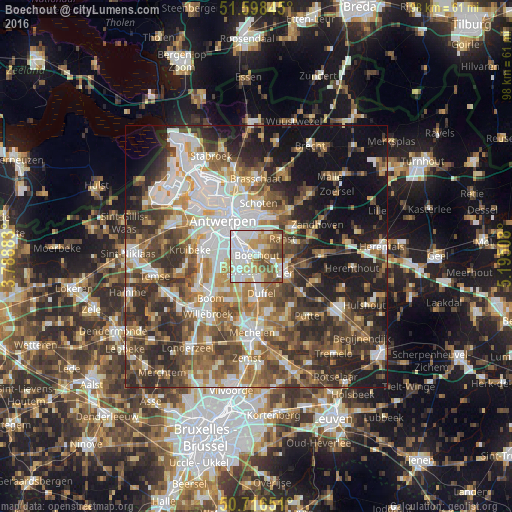
Analysis of Boechout night lights 2016
Square area 10x10 km:
100  28.74%
90-99 22.06%
80-89 10.29%
70-79 11.9%
60-69 6.15%
50-59 14.04%
40-49 5.88%
30-39 0.94%
20-29 0%
10-19 0%
0-9 0%
28.74%90-99
22.06%80-89
10.29%70-79
11.9%60-69
6.15%50-59
14.04%40-49
5.88%30-39
0.94%20-29
0%10-19
0%0-9
0%Square area 50x50 km:
100 10.45%
90-99 9.95%
80-89 4.81%
70-79 6.54%
60-69 7.83%
50-59 9.02%
40-49 9.75%
30-39 8.55%
20-29 11.82%
10-19 14.87%
0-9 6.38%
10.45%90-99
9.95%80-89
4.81%70-79
6.54%60-69
7.83%50-59
9.02%40-49
9.75%30-39
8.55%20-29
11.82%10-19
14.87%0-9
6.38%Clear (daylight) street map image can be seen on geolist.org.
Map coordinates:
51° 35' 54.4" North, 3° 47' 19.8" East
51° 9' 34.5" North, 4° 29' 31" East
50° 42' 59.4" North, 5° 11' 42.3" East
Some cities around Boechout sort by population:
• Mortsel
3 km =1.9 mi,  286°
286°
• Edegem
3.3 km =2.1 mi,  264°
264°
• Kontich
4.4 km =2.7 mi,  225°
225°
• Ranst
6.1 km =3.8 mi,  56°
56°
• Wommelgem
5.4 km =3.4 mi,  23°
23°
• Borsbeek
4.1 km =2.5 mi,  353°
353°
• Lint
3.6 km =2.2 mi,  174°
174°
• Hove
1.6 km =1 mi,  248°
248°
2801743 (p: 12,145)
Sources (retrieved 2019-11-25):
» Earth at Night: Flat Maps 2012, 2016