Rumst night lights from space
Night Light of Rumst (Flanders) from space (Belgium) Src. Average luminocity for 10x10km area is 79.0147% and for 50x50km: 59.118%.
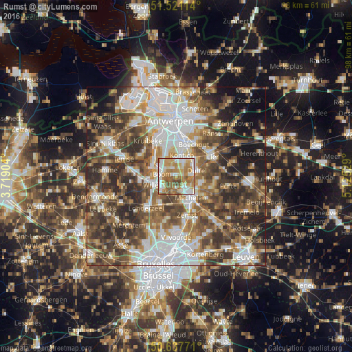
Analysis of Rumst night lights 2016
Square area 10x10 km:
100  16.18%
90-99 20.05%
80-89 11.76%
70-79 19.25%
60-69 18.45%
50-59 8.42%
40-49 5.88%
30-39 0%
20-29 0%
10-19 0%
0-9 0%
16.18%90-99
20.05%80-89
11.76%70-79
19.25%60-69
18.45%50-59
8.42%40-49
5.88%30-39
0%20-29
0%10-19
0%0-9
0%Square area 50x50 km:
100 13.64%
90-99 12.05%
80-89 5.81%
70-79 6.97%
60-69 8.96%
50-59 9.81%
40-49 11.42%
30-39 10.58%
20-29 11.15%
10-19 6.96%
0-9 2.63%
13.64%90-99
12.05%80-89
5.81%70-79
6.97%60-69
8.96%50-59
9.81%40-49
11.42%30-39
10.58%20-29
11.15%10-19
6.96%0-9
2.63%Clear (daylight) street map image can be seen on geolist.org.
Map coordinates:
51° 31' 16.1" North, 3° 43' 8.5" East
51° 4' 53.5" North, 4° 25' 19.8" East
50° 38' 15.8" North, 5° 7' 31" East
Some cities around Rumst sort by population:
• Mechelen
7.3 km =4.5 mi,  148°
148°
• Willebroek
4.9 km =3 mi,  241°
241°
• Kontich
5.9 km =3.7 mi,  17°
17°
• Duffel
6.3 km =3.9 mi,  75°
75°
• Boom
3.7 km =2.3 mi,  288°
288°
• Aartselaar
6.3 km =3.9 mi,  337°
337°
• Niel
7 km =4.3 mi,  298°
298°
• Lint
7.3 km =4.5 mi,  45°
45°
2787521 (p: 14,521)
Sources (retrieved 2019-11-25):
» Earth at Night: Flat Maps 2012, 2016