Hove night lights from space
Night Light of Hove (Flanders) from space (Belgium) Src. Average luminocity for 10x10km area is 84.393% and for 50x50km: 52.2197%.
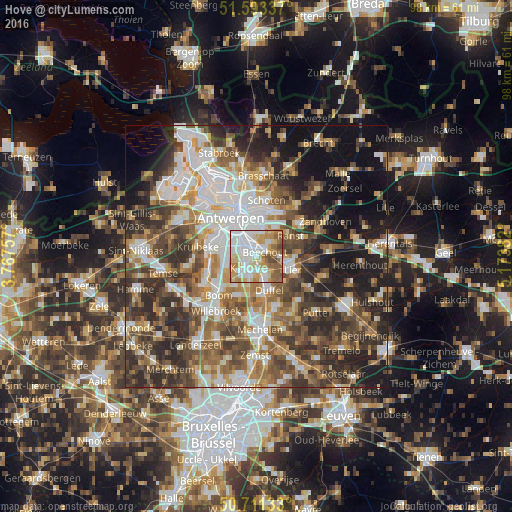
Analysis of Hove night lights 2016
Square area 10x10 km:
100  27.41%
90-99 22.99%
80-89 13.77%
70-79 13.77%
60-69 8.69%
50-59 10.29%
40-49 3.07%
30-39 0%
20-29 0%
10-19 0%
0-9 0%
27.41%90-99
22.99%80-89
13.77%70-79
13.77%60-69
8.69%50-59
10.29%40-49
3.07%30-39
0%20-29
0%10-19
0%0-9
0%Square area 50x50 km:
100 10.49%
90-99 10.15%
80-89 5.01%
70-79 6.61%
60-69 8.05%
50-59 9.05%
40-49 9.98%
30-39 9.03%
20-29 12.04%
10-19 13.29%
0-9 6.29%
10.49%90-99
10.15%80-89
5.01%70-79
6.61%60-69
8.05%50-59
9.05%40-49
9.98%30-39
9.03%20-29
12.04%10-19
13.29%0-9
6.29%Clear (daylight) street map image can be seen on geolist.org.
Map coordinates:
51° 35' 36.1" North, 3° 46' 3.3" East
51° 9' 16.1" North, 4° 28' 14.5" East
50° 42' 40.8" North, 5° 10' 25.8" East
Some cities around Hove sort by population:
• Mortsel
1.9 km =1.2 mi,  315°
315°
• Edegem
1.8 km =1.1 mi,  277°
277°
• Kontich
3 km =1.9 mi,  213°
213°
• Aartselaar
6.3 km =3.9 mi,  248°
248°
• Boechout
1.6 km =1 mi,  68°
68°
• Wommelgem
6.6 km =4.1 mi,  32°
32°
• Borsbeek
4.8 km =3 mi,  12°
12°
• Lint
3.5 km =2.2 mi,  149°
149°
2795232 (p: 7,968)
Sources (retrieved 2019-11-25):
» Earth at Night: Flat Maps 2012, 2016