Kyurdarmir night lights from space
Night Light of Kyurdarmir (Kürdǝmir) from space (Azerbaijan) Src. Average luminocity for 10x10km area is 15.4864% and for 50x50km: 0.9626%.
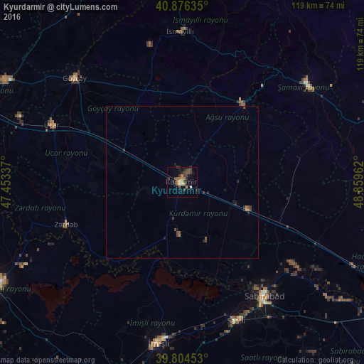
Analysis of Kyurdarmir night lights 2016
Square area 10x10 km:
 0%
0%90-99
0.68%80-89
1.7%70-79
2.89%60-69
3.4%50-59
2.38%40-49
3.57%30-39
5.1%20-29
4.76%10-19
4.76%0-9
70.75%Square area 50x50 km:
0%90-99
0.03%80-89
0.07%70-79
0.12%60-69
0.22%50-59
0.14%40-49
0.29%30-39
0.31%20-29
0.48%10-19
0.32%0-9
98.03%Clear (daylight) street map image can be seen on geolist.org.
Map coordinates:
40° 52' 34.9" North, 47° 27' 12.1" East
40° 20' 33.3" North, 48° 9' 23.4" East
39° 48' 16.3" North, 48° 51' 34.6" East
Some cities around Kyurdarmir sort by population:
• Saatlı
49.1 km =30.5 mi,  158°
158°
• Geoktschai
49 km =30.4 mi,  314°
314°
• Shamakhi
52.1 km =32.4 mi,  51°
51°
• Sabirabad
46 km =28.6 mi,  143°
143°
• Aghsu
32.7 km =20.3 mi,  39°
39°
• Ujar
46.8 km =29.1 mi,  294°
294°
• İsmayıllı
49.2 km =30.6 mi,  359°
359°
• Zardob
40.1 km =24.9 mi,  249°
249°
585763 (p: 19,088)
Sources (retrieved 2019-11-25):
» Earth at Night: Flat Maps 2012, 2016