Yeppoon city centre night lights from space
Night Light of Yeppoon city centre (Queensland) from space (Australia) Src. Average luminocity for 10x10km area is 20.9432% and for 50x50km: 2.5018%.
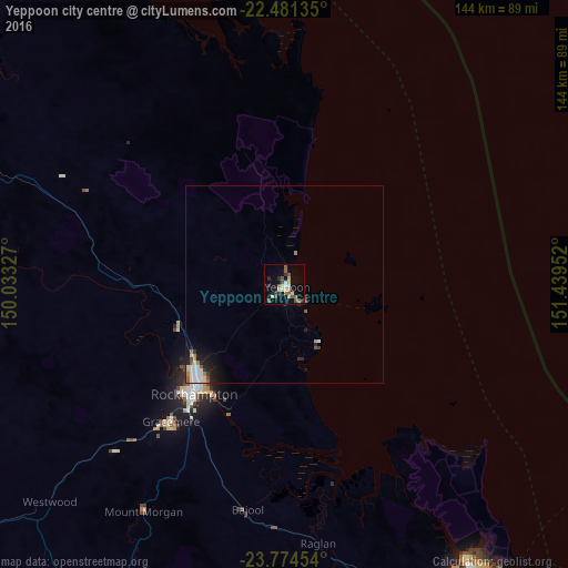
Analysis of Yeppoon city centre night lights 2016
Square area 10x10 km:
 2.27%
2.27%90-99
2.84%80-89
1.7%70-79
3.03%60-69
1.52%50-59
6.82%40-49
2.84%30-39
2.65%20-29
3.41%10-19
12.31%0-9
60.61%Square area 50x50 km:
0.43%90-99
0.47%80-89
0.2%70-79
0.17%60-69
0.31%50-59
0.42%40-49
0.31%30-39
0.25%20-29
0.57%10-19
1.49%0-9
95.38%Clear (daylight) street map image can be seen on geolist.org.
Map coordinates:
22° 28' 52.9" South, 150° 1' 59.8" East
23° 7' 46.2" South, 150° 44' 11" East
23° 46' 28.3" South, 151° 26' 22.3" East
Some cities around Yeppoon city centre sort by population:
• Rockhampton
36.5 km =22.7 mi,  220°
220°
• Gladstone
96 km =59.7 mi,  146°
146°
• Gracemere
44.6 km =27.7 mi, 219°
• Norman Gardens
30.9 km =19.2 mi, 223°
• Frenchville
31.2 km =19.4 mi, 218°
• Berserker
33.7 km =20.9 mi, 220°
• The Range
38.1 km =23.7 mi, 220°
• Park Avenue
33.4 km =20.8 mi, 221°
11523849 (p: 6,436)
Sources (retrieved 2019-11-25):
» Earth at Night: Flat Maps 2012, 2016