Yangebup night lights from space
Night Light of Yangebup (Western Australia) from space (Australia) Src. Average luminocity for 10x10km area is 77.3969% and for 50x50km: 36.2842%.
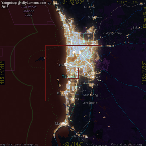
Analysis of Yangebup night lights 2016
Square area 10x10 km:
 16.26%
90-99
18.18%80-89
9.79%70-79
19.58%60-69
18.36%50-59
10.66%40-49
4.2%30-39
2.97%20-29
0%10-19
0%0-9
0%Square area 50x50 km:
7.77%90-99
8.17%80-89
4.01%70-79
5.11%60-69
7.49%50-59
5.08%40-49
3.57%30-39
3.27%20-29
5.64%10-19
8.24%0-9
41.64%Clear (daylight) street map image can be seen on geolist.org.
Map coordinates:
31° 31' 23.6" South, 115° 6' 47.2" East
32° 7' 14.3" South, 115° 48' 58.4" East
32° 42' 51.1" South, 116° 31' 9.7" East
Some cities around Yangebup sort by population:
• Hamilton Hill
5.3 km =3.3 mi,  319°
319°
• Success
4 km =2.5 mi,  127°
127°
• Spearwood
4 km =2.5 mi,  295°
295°
• Atwell
5.3 km =3.3 mi,  118°
118°
• Beeliar
1.7 km =1.1 mi,  213°
213°
• South Lake
2.4 km =1.5 mi,  63°
63°
• Bibra Lake
2.6 km =1.6 mi,  6°
6°
• Coolbellup
4.5 km =2.8 mi,  347°
347°
8349117 (p: 7,312)
Sources (retrieved 2019-11-25):
» Earth at Night: Flat Maps 2012, 2016