Beeliar night lights from space
Night Light of Beeliar (Western Australia) from space (Australia) Src. Average luminocity for 10x10km area is 70.3864% and for 50x50km: 34.9482%.
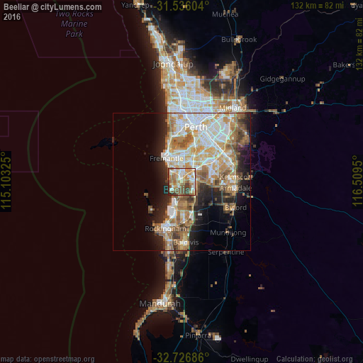
Analysis of Beeliar night lights 2016
Square area 10x10 km:
 13.11%
90-99
13.64%80-89
8.92%70-79
14.34%60-69
16.78%50-59
14.16%40-49
9.27%30-39
6.12%20-29
3.67%10-19
0%0-9
0%Square area 50x50 km:
7.15%90-99
7.62%80-89
4%70-79
4.99%60-69
7.44%50-59
5.08%40-49
3.62%30-39
3.26%20-29
5.54%10-19
8.09%0-9
43.21%Clear (daylight) street map image can be seen on geolist.org.
Map coordinates:
31° 32' 9.7" South, 115° 6' 11.7" East
32° 8' 0.2" South, 115° 48' 22.9" East
32° 43' 36.7" South, 116° 30' 34.2" East
Some cities around Beeliar sort by population:
• Hamilton Hill
6 km =3.7 mi,  334°
334°
• Success
4.2 km =2.6 mi,  104°
104°
• Spearwood
4.1 km =2.5 mi,  319°
319°
• Atwell
5.7 km =3.5 mi, 101°
• Yangebup
1.7 km =1.1 mi,  33°
33°
• South Lake
3.9 km =2.4 mi,  51°
51°
• Bibra Lake
4.2 km =2.6 mi,  16°
16°
• Coolbellup
5.8 km =3.6 mi,  359°
359°
8347945 (p: 7,293)
Sources (retrieved 2019-11-25):
» Earth at Night: Flat Maps 2012, 2016